ACHIEVING SUSTAINABILITY FOR THE GREATER KOCHI REGION-THE DIRE NECESSITY, A GLOBAL TO LOCAL APPROACH
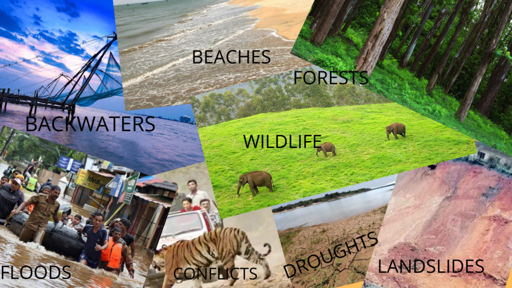
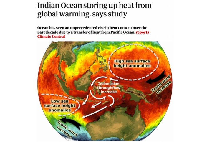
The Indian Ocean is the Global Heat Hub and the Arabian Sea at the Western Boundary of the Indian Peninsula carries more heat being landlocked on its three sides, it is learnt from research publications and experts. Mini-cloudbursts, depressions, floods and landslides may be harbingers to the disasters in the offing on colossal scales. Though it is a global-scale phenomenon it has to be dealt with local solutions to save and protect millions of inhabitants and fulfil their aspirations.
This paper discusses the possible Spatial Planning Solutions based on innovations to bring environment and development hand-in-hand more so the southern part of Central Kerala flanked by Vembanadu Estuary abutted by the Arabian Sea in the West, Chalakudy and Achancovil rivers on the North and South each, and the Western Ghats at the east. There are many ecological hotspots, reserved forests/protected areas and a network of reservoirs which also include Mullaperiyar Dam which caters water to our neighbouring State of Tamil Nadu and which is under dispute to be decommissioned or to be strengthened. This region is the highly urbanised region in the State of Kerala which includes Kochi Urban Agglomeration(UA) the biggest UA in the State.
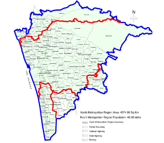
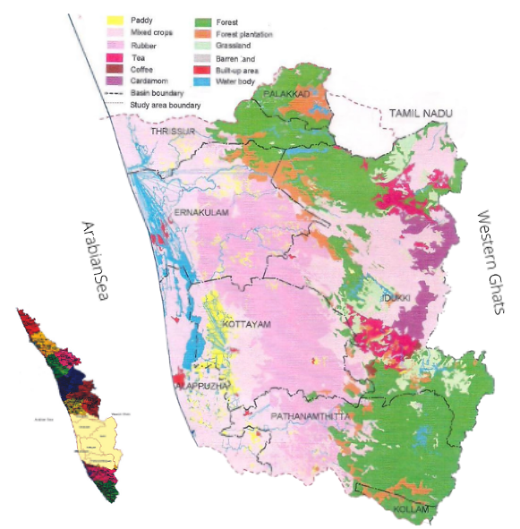
A study conducted by a consortium of experts from the Kochi area under the aegis of the Ministry of Environment, Forests and Climate Change(MoEFCC) identified an area of 14931 Sq.km which is named as Greater Kochi Region. There are seven west-flowing rivers Chalakudy, Periyar, Moovattupuzha, Meenachil, Manimala, Pampa and Achancovil which drain down from the Western Ghats to the Vembanadu Estuary. The traditional economic base, Cochin Port is located right in the Vembnadu Estuary merging with the Arabian Sea. Apart from Kochi Metropolitan Declared Area containing the biggest urban agglomeration in the state, there are many urban local bodies. The earmarked area mainly includes three districts in full (namely Ernakulam, Kottayam and Idukki) and three districts in part (Thrissur, Alappuzha and Pathanamthitta). The highest mountain peak of Anamudi to the lowest areas of Kuttanadu(below mean sea level) is located in this area. The identified area consists of 7 drainage basins. Both from an environmental and development point of view, this area deserves attention considering the eco-system limitations and development potential of the area.
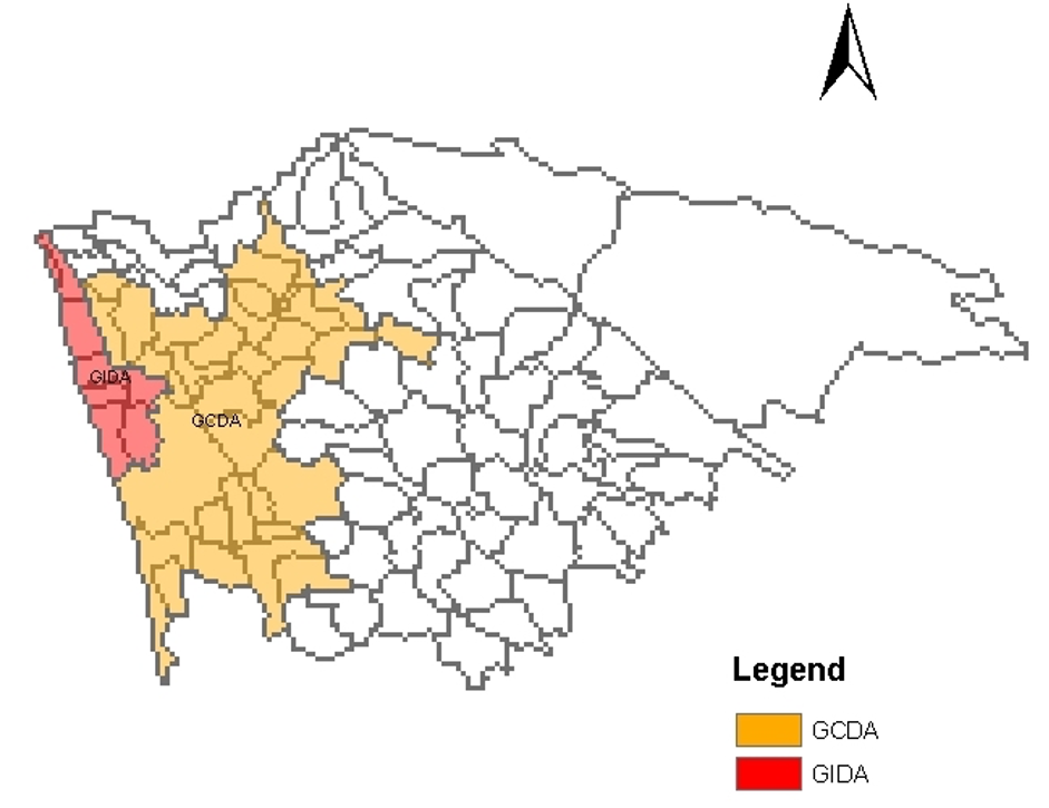
Kochi UA is declared as a million-plus city as per the Census of India 1991. This was the only UA in Kerala having a million-plus status in 1991 as per the Census Report. After the Government of India’s 73rd& 74th Constitutional Amendment Acts of 1992 and Kerala Panchyat Raj & Municipalities Acts of 1994, Govt of Kerala declared Kochi Metropolitan area extending to 732 Sq. Km and comprises two development authorities, Greater Cochin Development Authority (632 Sq. Km) and Goshree Island Development Authority (100 Sq. Km). This is the original jurisdictional area of Greater Cochin Development Authority Constituted in 1976 by upgrading the status from Cochin Improvement Trust formed in the year 1968.
This area delineation was done after a Scientific Regional Study conducted by the Department of Town Planning in the 1960s. The Study Report is known as ‘Development Plan for Kochi Region’. This report could not be made a legal document as there were no provisions in the Town Planning Acts prevalent in the state then. Provisions were there only to do Master Plans for the Towns/Cities as per the Madras Town Planning Act of 1920 and Travancore Town Planning Act of 1932 which were not repealed till 2016. These acts have been replaced by the Kerala Town and Country Planning Act of 2016 in line with the Constitutional Amendment Acts of 1992.
The influence Region of Kochi scientifically earmarked by the team of experts in the 1960s was going beyond Ernakulam District Boundary. While constituting the Greater Cochin Development Authority, the area was delimited to contain in Ernakulam district to ensure administrative convenience. It is ironic to note that the earmarked area remains the same even after 56 years. Efforts have been made by the Greater Cochin Development Authority to re-delineate the area by including highly urbanized Community Development(CD) Blocks of adjoining districts of Thrissur, Kottayam, and Alappuzha which do influence Kochi Core area along with Ernakulam District in full which comprises both urban as well as rural areas. This is to inculcate a symbiotic relationship between urban and rural areas in the region by promoting balanced human development in the urban areas while ensuring ecosystem services in the rural areas. As per the Millennium Ecosystem Assessment Report of 2005 (MA 2005) apart from the fresh agricultural and forest products for consumption the ecosystems have supporting, regulatory and cultural services.
(Source: Greater Cochin Development Authority)
Blessed by the northeast and southwest monsoons, Kerala has a very good physical quality of life. The availability of potable water and fertile land all over Kerala is enriched by 44 rivers which ensured water-based transport systems too. The rivers mainly are short, steep and fast following. The Greater Kochi Region earmarked under the aegis of MoEFCC have 7 west-flowing rivers originating from the Western Ghats and merging with the Vembanad Estuary. The Greater Kochi Regional delineation has been carried out based on the river systems and drainage basins. It is more justified as water-based environmental imbalances can occur due to climate change and related changes in rainfall patterns that have already been noticed in the region.
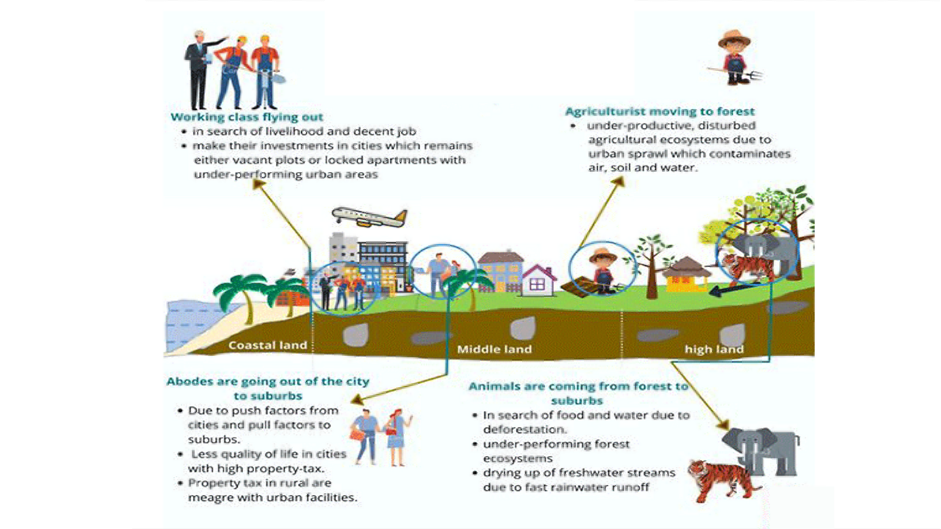
Kerala’s urbanisation is limited to 47.7% only on economic performance criteria – more than 75% of the male working population engaged in non-agricultural activities- among the four-fold criteria of the Census of India. If this 4th criterion is set apart the whole of Kerala can be urban. Kerala’s trend is unique compared to the rest of the country. There is no dedicated research to correlate the socio-economics visa–a-vis urbanization characteristics of this peculiar phenomenon in the State. One thing is confirmed that Kerala’s Urban Density is diminishing decade after decade which are signs of urban sprawl.
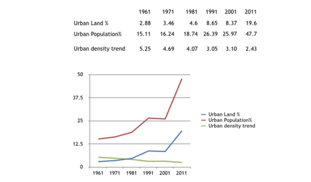
The business-as-usual scenario of Kerala is depicted below and urban sprawl can be the sole reason for the Kerala situation where the economic base of the state is the NRI remittances. A large number of Kerala houses remain locked and non-performing. The ecosystems are under-nourished due to the lack of eco-system integrity while the economy is not attained in urban centres due to pilferage in the form of fossil fuel losses and spare capacity.
INNOVATIVE APPROACH FROM GLOBAL TO LOCAL
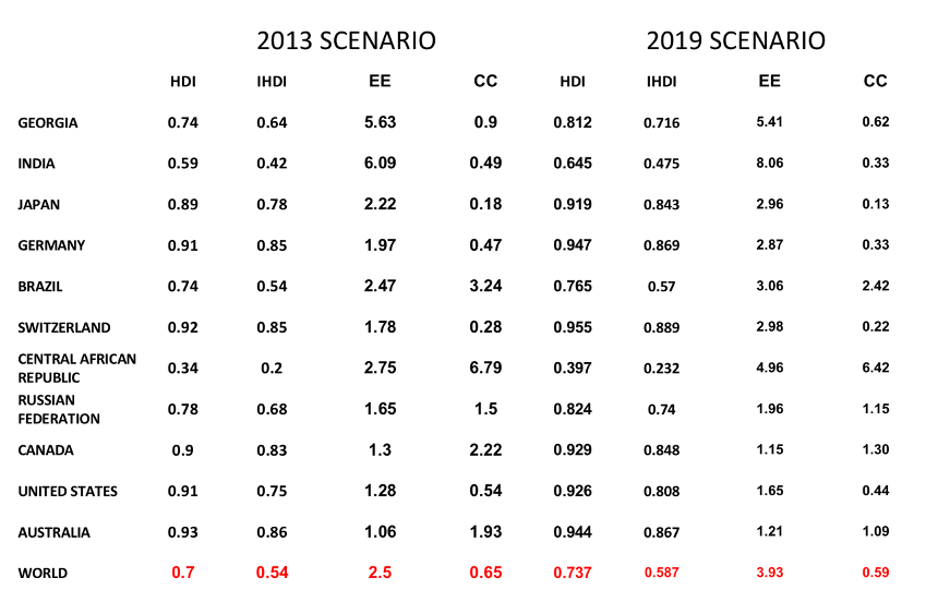
Based on research reports of UNDP and Global Footprint Network two strong indicators of sustainability have been evolved which are Environmental Efficiency and Carrying Capacity (EE&CC) and which are like two sides of a coin. After HDR 2010, the HDI concept of UNDP has been improvised by calculating the ‘Inequality Adjusted Human Development Index(IHDI)’. Necessary discounting on health, education and income achievements are carried out in lines of inequality prevalent in different sectors and the geometric mean is considered as they are mutually dependent.
Similarly, Global Footprint Network, California based International NGO, led by Dr Mathis Wackernagel, combines three factors of consumption namely energy, land-use and productivity and is expressed in Global Hectares(gha). Productivity of the land is incorporated in the calculations by comparing the average global productivity of the particular land use. Ecological footprint(total consumption) and biological capacity are calculated in global hectares wherein forest land for carbon dioxide sequestration is the major part.
Two strong indicators, EE & CC, are evolved based on an Output / Input Approach and Capacity /Consumption Approach. As per the Global Footprint Calculations, the World has started over-shooting from the 1960s and the phenomenon is aggravating to multiple scales as the years pass by. The Pandemic spread, floods, hurricanes, forest fires and heatwaves are killing millions of people and causing discomfort and anxiety. They are harbingers to dire situations in the coming years.
There are several methods by which EE & CC can be brought to the local level
- By following the methodologies and calculations done by UNDP and Global Footprint Network for the States, Metropolitan Regions and Local Bodies within the Region and Districts.
- By identifying and aggregating the broad and mutually exclusive indicators which are contributing to balanced human development, reducing the ecological footprint or both. There are environmental efficiency multiplying indicators such as the number of people covered by Mass Rapid Transport Systems, wherein both human development enhancements and ecological footprint reductions happen.
- Using the capabilities of Remote sensing and Geographical Information Systems(RS&GIS) it is possible to evaluate the EE&CC status of the region using mutually exclusive proxy indicators contributing to balanced human development, reducing ecological footprint or contributing to biological capacity of ecosystems.
EE&CC mapping for the region can be done based on classified images transformed to vectors and dividing the area into grids of appropriate size, say 1 Km by 1 Km. The following are identified to incorporate as proxy indicators to evaluate the EE&CC status of various grids.
i) land utility based on the degree of common ownership of land,
ii) accessibility in terms of distance and time
iii) percapita built-up area based on the degree of high rise buildings,
iv) ecosystem disturbance reversal and productivity multiplication to positively account for bulk developments.
v) the degree of fragmentation of supporting regions based on ownership and subdivisions carried out.
Using this methodology EE-rich and CC-rich areas can be identified, so also, EE-prone and CC-prone areas. Urban Sprawl tendencies can be sealed by transferring the development rights(TDRs) from CC-prone areas to EE-prone areas. Compact development can be inculcated in EE-prone areas while ecosystems with high integrity can be inculcated in CC-prone areas. If TDRs are accounted in a BLOCKCHAIN Platform it can ensure transparency accountability. Once this is achieved a symbiotic relationship between cities and their region is established where Environmental Efficiency is achieved in Urban Centres while Carrying Capacity is achieved for the supporting regions.
PROPOSED INSTITUTIONAL SETUP
In this situation, a dedicated agency is required to monitor and regulate the urban-sprawling tendencies in the State and its Regions as they cause a regression to the state in multiple ways. As per the Kerala Town and Country Planning Act of 2016 and subsequent notifications the present Greater Cochin Development Authority is identified as a nodal agency that can do activities such as Transfer of Development Rights(TDRs). It is to be empowered with constitutional backing to perform the mandates effectively. This shall act as the technical secretariat of the MPC for the Greater Kochi Region based on the 73rd & 74th C.onstitutional Amendment Act of 1991, Kerala Municipalities& Panchayat Raj Act of 1994 and Kerala Town and Country Planning Act of 2016. Greater Cochin Development Authority shall be renamed as Greater Kochi Metropolitan Regional Development Authority.
Metropolitan Planning Committee(MPC) shall be constituted for the whole of Greater Kochi Region which is a meso-region above districts containing highland, middle land and low land. The Western Ghats Ecology Expert Panel under the leadership of Prof. Madhav Gadgil also mentions the formation of MPCs in line with Calcutta MPC, constituted above 5 districts in W. Bengal. District Panchayats(Zilla Parishads) and Urban local bodies will be reporting to the MPC. Based on the EE&CC status of grids the Metropolitan Regional Plan is to be prepared to ensure Human Welfare and Prosperity on one side while Carrying Capacity on the other side. If any of the EE-rich grids are prone to hazards, as per the hazard maps prepared, they are to be dealt with engineering solutions.
Once this is set up and the process is implemented similar metropolitan regions can be identified including all the million plan UAs in the State and the abutting regions to seal the Urban Sprawl tendencies to achieve EE rich development and CC rich ecosystems.
References:-
1.World Resources Institute. Millennium Ecosystem Assessment. 2005. Ecosystems and Human Well-being: Biodiversity Synthesis. Washington, DC
2. Khan. B.2015. Indian Ocean Storing up heat from Global Warming. Guardian Environmental Network
3.National Environmental Engineering Research Institute.2003. Dissemination Package.Carrying Capacity based Development Planning for Greater Kochi Region.Nagpur.India
4.Department of Town Planning.1977.Development Plan for Cochin Region.Government of Kerala(Unpublished Report)
5. http://hdr.undp.org/en/content/hdr-technical-notes
6.Global Footprint Network.2013 and 2019.National Footprint Accounts.Data Package.Oakland.USA


You choose peace or war?
Peace definitely
Peace and tranquility to all through EE&CC applications which are improvised as may&ton values
Good day! I just wish to give you a huge thumbs up for your excellent information you have got here on this post. I am coming back to your blog for more soon. Good day! I just wish to give you a huge thumbs up for your excellent information you have got here on this post. I am coming back to your blog for more soon. נערות ליווי במרכז
Thanks for your KUDOS. Now it is your duty to spread this message to the people around you.
Im very happy to find this web site. I want to to thank you for ones time just for this fantastic read!! I definitely appreciated every part of it and i also have you saved as a favorite to see new information in your blog.
Thank you for your good words. In fact this is my mission where all my personal to professional goals are met. Please stand with me in propagating the innovative concepts of EE&CC as I am confident that it can change the world to the most sustainable path.
An intriguing discussion is worth comment. I do think that you should write more on this topic, it might not be a taboo subject but typically folks dont discuss these issues. To the next! All the best!!
These kind of thought processes are to be inculcated from kindergarten onwards.
Good article. I definitely appreciate this website. Stick with it!
Everything is very open with a precise explanation of the challenges. It was truly informative. Your website is extremely helpful. Many thanks for sharing!
Really inspiring message
Experience the full power of an AI content generator that delivers premium results in seconds. 100% uniqueness,7-day free trial of Pro Plan, No credit card required:). Click Here:👉 https://stanford.io/3HrAujq
Can I simply just say what a relief to uncover someone that truly understands what theyre talking about online. You certainly realize how to bring a problem to light and make it important. A lot more people have to check this out and understand this side of your story. I was surprised you arent more popular given that you definitely have the gift.
I was excited to uncover this site. I need to to thank you for your time for this particularly wonderful read!! I definitely savored every part of it and I have you saved to fav to see new stuff in your site.
Excellent blog post. I certainly love this website. Keep it up!
Good post. I learn something totally new and challenging on websites I stumbleupon every day. Its always exciting to read articles from other writers and practice a little something from other sites.
I need to to thank you for this good read!! I certainly enjoyed every little bit of it. I have got you book-marked to check out new things you postÖ
I have to thank you for the efforts youve put in writing this blog. Im hoping to check out the same high-grade blog posts by you later on as well. In fact, your creative writing abilities has encouraged me to get my own website now 😉